The Grid tab provides the options by which the user may set the vertical layering system, set masks, and also set the model position at its center as shown in 2389722 Figure 1. The Sigma Zed (SGZ) vertical layering option is implemented with EFDC+ alongside the previous option of Standard Sigma grid (SIG). A drop-down option for the Water Layers is provided and the options described below.
...
A comparison of SIG and SGZ grids is shown in 2389722 Figure 2.
| Anchor | ||||
|---|---|---|---|---|
|
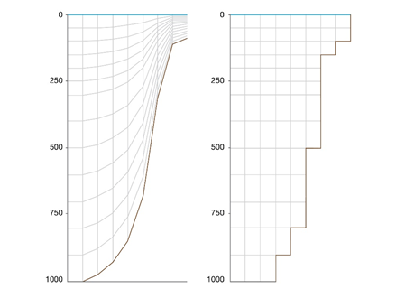
Figure 2 Vertical grids for Sigma stretch (left) and Sigma Z (right).
The model grid specification as SIG or SGZ can be made in the main form of EE from the Domain tab | Grid sub-tab as shown in 2389722Figure 3. The first option Standard Sigma is the conventional gridding scheme of EFDC model.
...
In the Masks frame the Use check box enables the user to enable masks (zero thickness flow barriers) in EFDC. The MASK.INP file will then be required by EFDC. EFDC_Explorer can generate and modify masks using the Modify button as shown in 2389722 Figure 4. The Create Masks utility does not automatically turn on the mask computation, it just generates the masks and writes the MASK.INP file. The user must manually click the mouse cursor inside the Use Masks check box to use the masks generated.
...
Latitude and longitude settings the center of model are accessed in Domain | Grid | Model Position at Centre as shown in 2389722 Figure 1 above. These settings are required for EFDC+ to calculate solar radiation as well as mapping features in EE. The user should select the Modify button to update these values. If the user has not entered a UTM zone for the model the default will be UTM zone 10 and the Northing and Easting will be set to the model centroid. EE reads the UTM zone from C91 (netCDF settings) in the EFDC.INP and updates to the latitude and longitude are stored in C46C (atmospheric location and wind function coefficients). Northing and Easting values are calculated based on the UTM and lat/long values.